Most people take pictures of their food before they eat them, but I could not wait.
First time I heard about Runza was in Ogallala, NE, when a car salesman told me to go get one while my new car was being prepared for me to continue my drive to Arkansas in 2015.
So I went there in a loaned car and had beef, cabbage and onions wrapped in homemade bread. It’s been that way since 1949 when Sally Everett started selling them from a carhop stand in Lincoln, NE.
Then her son, Don, franchised the restaurants, sold Runza across from Memorial Stadium until he moved inside and started selling them from food trucks.
Now there are 80 locations – all within the state of Nebraska. Why not expand outside the state? A question they must hear a lot. So at the Runza in McCook, NE, there is a sign that answers that question:
“Well, we don’t want to be the largest restaurant chain around. We do want to be among the best. That’s why we pour our heart and soul into every store. To maintain this level of hands-on support, proximity plays an important role in our growth strategy.”
Even if you love beef and cabbage, it’s probably not worth driving to Nebraska. But if you are passing through, stop.
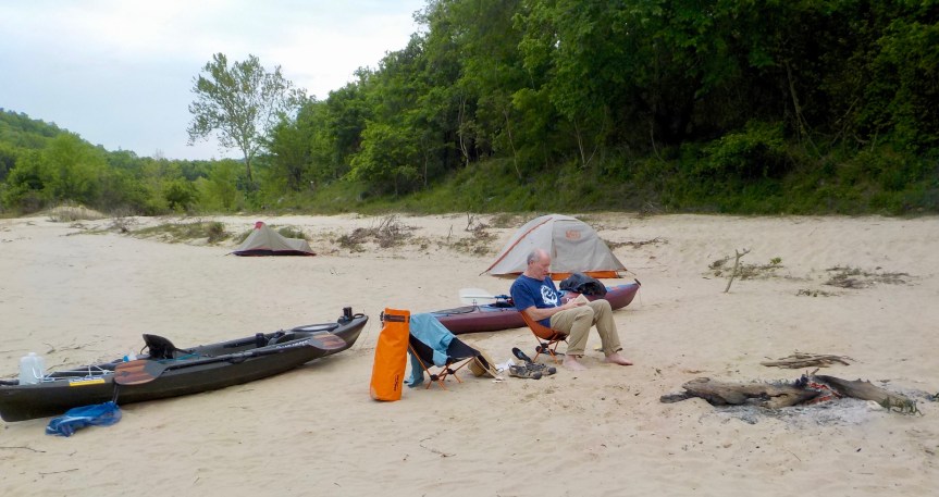
Ian about to launch on a rainy morning. Sorry about the rain on the lense.
Buffalo River III, Third day — When sleeping in a tent, there’s nothing like a peal of thunder and a flash of lightning to get you up in the morning – especially when it is 1:30 a.m and still dark outside.
That’s what woke us up on our third day on the Buffalo River in Arkansas. The nice thing about the lightning flashes is that you can see how much it is raining. In this case it was one of those big-drop rainfalls that spent the next five hours forming puddles around and then under my tent. So far my MSR one-man tent has always kept me dry without a ground cloth underneath it. I’ve heard too many stories about wet campers from the under liner sticking out from under the tent and collecting pools that come inside. But having now experienced what can happened when water pools under your no-ground-cloth-for-me tent, I can say that a custom cut tarp goes with me the next time.
I had planned to stay snuggled in my sleeping bag and tent until the rain stopped (sometime in August?). But when Ian was outside asking, “Are you awake in there” at 6 a.m., my dry spot in the tent had dwindled to an area almost big enough for me in a fetal position – almost. Foot of the sleeping bag sopping wet. Starting to leak around my head. Time to get up.
Last two miles of the Buffalo River in the rain.
We bundled up wet tents, sleeping bags (for me), clothes and were on the water in rain gear by 7:30 a.m. We had planned the trip to have only a few miles left to paddle on the last day. Which worked out even better in the pouring rain.
Riley’s Dock, our take-out spot, was across the White River from where the Buffalo River empties into it. We chose this as our end spot at the suggestion of Dirst Canoe Rental, which shuttled my truck from Buffalo Point to here. It avoided a half-mile upstream paddle on the White, which could be flowing big time if the Bull Shoals Dam 10 miles up the river was open. Or, we could have paddled downstream on the White five miles or so.
But to get to Riley’s Dock, all you had to do was turn left as you came into the White, paddle 200 yards or so upstream and then drift across the river onto the far side of Smith Island. The dock would be nestled behind a smaller island on the other side. My left turn did not work and I ended more out in the White than I wanted to be. But I remembered Jack, our canoe pod leader on the Willamette River trip in Oregon, telling us about making your kayak into an airplane wing: Angled upstream across the river and with water pushing against your kayak on one side but not on the other, you’ve created a vacuum that keeps planes up in the air and your kayak pushing upstream against the current. And it worked. Still had to paddle, but I rounded Smith Island and headed for home.
Ian made the left turn, got high enough upstream to turn right and dash across on a downstream slant, arriving at the dock just before me.
Riley’s Dock
Great people at Riley’s Dock. Five bucks to back the truck down the boat ramp to unload kayaks, and they offered a warm, dry cabin for us to change out of wet clothing.
Ian’s tide water marker a yard or so off the river.
Ian had set out tidewater stakes at our campsite the night before to see how far the river might come up. No noticeable change when we got up this morning, but the folks at Riley’s Dock said the rise in the river was now in Ponca, 130 miles or so up the river.
“It will be here this afternoon,” they said.
Two toads slept under my tent the last night.
And boy did it. I dropped Ian in Springfield, MO, for his flight back to Seattle, and he messaged me later that the river had gone up 12 feet that day. With or without ground cloth, my tent would not have had a dry spot big enough for the toads that jumped out from under it this morning.
We hit it just right. We started on April 29, when the river was dropping below six feet of gage height – above that and rangers recommend only experienced paddlers on the river. It kept dropping on April 30, but then look at the line shooting up on May 1, almost to 18 feet by the end of the day. We’d have been in New Orleans by the end of the week.
Second day on Buffalo River, Arkansas, Part III — We were up early – around 6 a.m. – but spent a long time at breakfast, getting our gear in order, loading the boats and finally launching around 8:45. We had pored over our maps and figured out that we had paddled up Big Creek on the first day while searching for the Cold Springs schoolhouse, which we never found. The paddle upstream was a hard one, probably because Big Creek is the second largest tributary to the Buffalo River adding nine percent of the full load. Still, it was nice to figure out where we were.
Some wind today but the current kept us going whether we paddled or not. A couple of ripples that kept us on our toes but nothing like at Clabber Creek Shoal on the first day.
Standing in front of Elephant Head. I think I am looking serious because of the huge responsibility of taking the selfie.
We used Elephant Head rock as a place we would know exactly where we were on the map. How could anyone miss a 210-foot high rock shaped like an elephant? We paddled another mile or two and stopped in front of Grayface Bluff. Ian suggested we set up the tents first, and it was a good thing we did as we retired to them as some big-drop rains fell on us.
Our second camp, up high in the sand and rocks.
Once outside in the evening, Ian put his book away and watched the buzzard and occasional eagles overhead. “I can read anytime, but when can I watch buzzard playing in the thermals on a bluff over the river” We wondered if they were scouting for carrion to make a group meal or if they were drifting back and forth over the bluff for fun, which is what we agreed we’d be doing.
(Ian admits the sound in the video above is terrible, but what I am saying is we are starting a 30-mile float trip on the Buffalo River in Arkansas and the bridge behind me was underwater in the 1982 flood.)
The guidebook describes the Clabber Creek Shoal as the “wildest rapids of the lower river.”
That’s a lie.
It’s the wildest rapid on all 135 miles of the Buffalo River in Arkansas, from Ponca down to the White River. I know because after my third trip there recently, I have floated all those miles over all those rapids.
The book “Buffalo River Handbook” by Kenneth L. Smith, talks about Clabber Creek Shoal current going right, then left, don’t get swept into the right bank and don’t get swamped by the haystacks.
Haystacks? Odd thing to have in the river.
Since then I have learned that “haystack” waves are not like the riffles, wave trains and strainers and stags I had glided happily over or have avoided on previous trips on the Buffalo. Haystacks don’t move downstream as you do; they stay right there where some underwater rock – or rocks – put them.
I, in my ignorance and hubris, figured I’d have no problem. Even a 275-prop will come down if you aim your tackle low enough.
No problem avoiding the right bank. On to the haystack waves, bow first and over the top as I always once did. I got up and over one. Sloughed through another and looked into the base of a Cecil B. DeMille wave. Sometimes the prop runs over you, and the Red Sea wave wins no matter where you aim your attack.
It flicked my kayak over to the left, and I remembered two things as the kayak turned: Stay with the boat and don’t lose your paddle. Fortunately, all my belongings were well attached. Dry bags, water jugs and carabiners all held to my new shock cords. My hatch cover leaked some, but tent, sleeping bag, camp chairs and coats (a bit damp) all stayed aboard.
The only things dumped into the river were unattached: the map case, my Stanley coffee thermos and me.
I pulled myself up over the overturned boat with my paddle in hand and peeked over the hull to see my thermos headed for the goal line. Kicking for shore with two legs and one arm as down the river we went.
Ian, my partner, took his kayak to the left of the haystacks, stayed upright and then did things in the right order. First getting the map case, then the thermos and finally towing me and kayak the last few yards to shore.
Mostly wet and checking my fogged binoculars. Photo by Ian Gunn
The underwater camera seems to be working fine, but looking through the binoculars (in the pocket of my life vest, which I was wearing) is like examining a one-celled animal swishing around on a fogged microscope slide.
Up until then, the trip had gone swimmingly. We launched at Dillard Ferry, upstream from Buffalo Point, and got to what we thought would be our first night’s camping spot at noon. So we decided to push on to the second night camp spot. We needed the rescued maps and Ian’s GPS to try to find it, and never did. But it’s hard to get lost when the river is pushing you downstream.
First night’s campsite.
We found a great campsite but unfortunately followed some awful campers. Fire still smoldering, cigarette butts everywhere, soap and other trash strewn around and the TP flowers nearby with their white and brown blossoms.
Rekindled the fire, dried out clothes in sun, cooked, ate, read and to bed in skivvies – although the long johns are nearby.
Traveling in the past couple weeks in the land of long poled squeegees where you can mop the suds off your truck windshield without standing on your tire or reaching through your opened front door. Out of the short-sticked cities like Seattle, Denver, Wichita, Omaha and Kansas City, and out into the Midwest countryside to visit Huntington, OR; Flagler, CO; Fall River, KS; Iola, KS; and Chadron, NE, in a two week drive to a float trip on the Buffalo River in northern Arkansas.
Camping near Flagler, CO.
“Afoot and light-hearted I take to the open road,
Healthy, free, the world before me,
The long brown path before me leading wherever I choose.”
Thank you, Walt, and I’m sure you would appreciate a trip across America to look at the country and “check on the crops,” as my parents and grandparents used to say before starting out on each evening’s drive.
From driveway to driveway clocked 4,047 miles across 13 states, listened to all my songs from “Nada de Nada” by Braho to Paul Robeson’s version of the “Song of the Volga Boatmen.” Became a fan of Michael Smerconish on Sirius Radio and wondered how long a stick Mark Levin was sitting on. That yelp, that nasty attitude.
Farmers just poking their heads out to prepare grounds for planting. Past fields of green wheat, corn stubble and one large field of uncut soybeans, perhaps not worth the harvest expense when penciled against the crop prices undercut by tariffs.
Sunrise at Fall River State Park, KS.
Oil wells starting in Russell, KS, which led to the question: What are they pumping into? Never anything there that looks like it could hold as much as a 55-gallon barrel. Underground?
Also went against the advice of the President and took a big risk of cancer by driving through the wind turbines near Sylvan Grove, KS. But worth it to get out of southern Wyoming. Every land has something of value, something worth looking at, but southern Wyoming from Evanston to Cheyenne may come the closest to that know-nothing description used by transportation planners and realtors: “vacant land.” All I can say for this trip is that it wasn’t snowing and Interstate 80 was open.
But enough of criticism:
“Henceforth I whimper no more, postpone no more, need nothing,
Done with indoor complaints, libraries, querulous criticisms,
Strong and content I travel the open road.”
Because of a late rain on our river trip (more in a later post), I was on the road a day early for my return trip but not early enough to reach my favorite Indian casino in Sloan, IA, the WinnaVegas Casino Resort, before dark. (How can you see America in the dark?) A large casino in a large field where patrons the last time I was there were talking about harvesting corn while a short lady threw tens from arms that barely cleared the rail around the dice table. They bet hard tens, I stayed on the pass line.
Without the planned trip to WinnaVegas, that meant I could strike out anywhere on my path back to short-sticked Seattle. Getting out the maps, I noticed that U.S. Highway 24 goes all the way across the state of Kansas.
Route 24 was a big deal in my childhood and an even bigger one later when its expansion looked like it would go through our farmland. My bumper sticker showing a highway sign of Hwy. 24 with a prohibited mark over it perplexed many in Seattle. But that battle is over and done with, and there will be no remorse, no hard feelings here.
“They pass, I also pass, any thing passes, none can be interdicted,
None but are accepted, none but shall be dear to me.”
Compared to one-lane rural roads in Northwest Ohio, 24 could handle barreling semis, brook no stop signs and travel on to Toledo in one direction and who knew where in the other. Turns out it may be the only thing that connects Toledo, OH, with Vail, CO. Hard to imagine someone in Vail building a road to Toledo. More likely the other way around.
“Don’t ride your bikes on 24,” my folks said.
“We drove on 24 in drivers’ training class today,” we said after scaring Mr. Bard half to death as we traveled further to getting our licenses.
So from Rossville, KS, to just past Menlo, KS, where I turned north to head into Nebraska, I drove on 24, a two-lane blacktop except where planners decided to take some vacant land from some farmer and add two more rows of concrete (Oops, I forgot. No more whimpering). With Mrs. Mabel Apple in the GPS forever telling me to turn left and get on Interstate 70, it was just like Mom saying, “Don’t ride on 24.”
But I did.
“Allons! the road is before us!
It is safe—I have tried it—my own feet have tried it well—be not detain’d!”


 But to get to Riley’s Dock, all you had to do was turn left as you came into the White, paddle 200 yards or so upstream and then drift across the river onto the far side of Smith Island. The dock would be nestled behind a smaller island on the other side. My left turn did not work and I ended more out in the White than I wanted to be. But I remembered Jack, our canoe pod leader on the Willamette River trip in Oregon, telling us about making your kayak into an airplane wing: Angled upstream across the river and with water pushing against your kayak on one side but not on the other, you’ve created a vacuum that keeps planes up in the air and your kayak pushing upstream against the current. And it worked. Still had to paddle, but I rounded Smith Island and headed for home.


 Without the planned trip to WinnaVegas, that meant I could strike out anywhere on my path back to short-sticked Seattle. Getting out the maps, I noticed that