
Category: Hiking
EXPLORE Act: How did I miss it?
The Senate has unanimously passed the EXPLORE Act, which is now headed to President Biden’s desk for signing. The House passed it in April. As this article points out, the bill includes the Biking on Long Distance Trails Act (BOLT) to identify and create more long-distance bike trails, the Protecting America’s Rock Climbing Act (PARC) to safeguard Wilderness climbing, the Simplifying Outdoor Access for Recreation Act (SOAR) that will improve recreational permitting for outfitters and guides, and permanent direction for the Outdoor Recreation Legacy Partnership and FICOR.
Never saw the passage of this bill coming, But glad it is becoming law before January 20, 2025.
For full text of the bill, see here: https://www.congress.gov/bill/118th-congress/house-bill/6492/text
Utah bike ride, Day 5 — and a hike, too
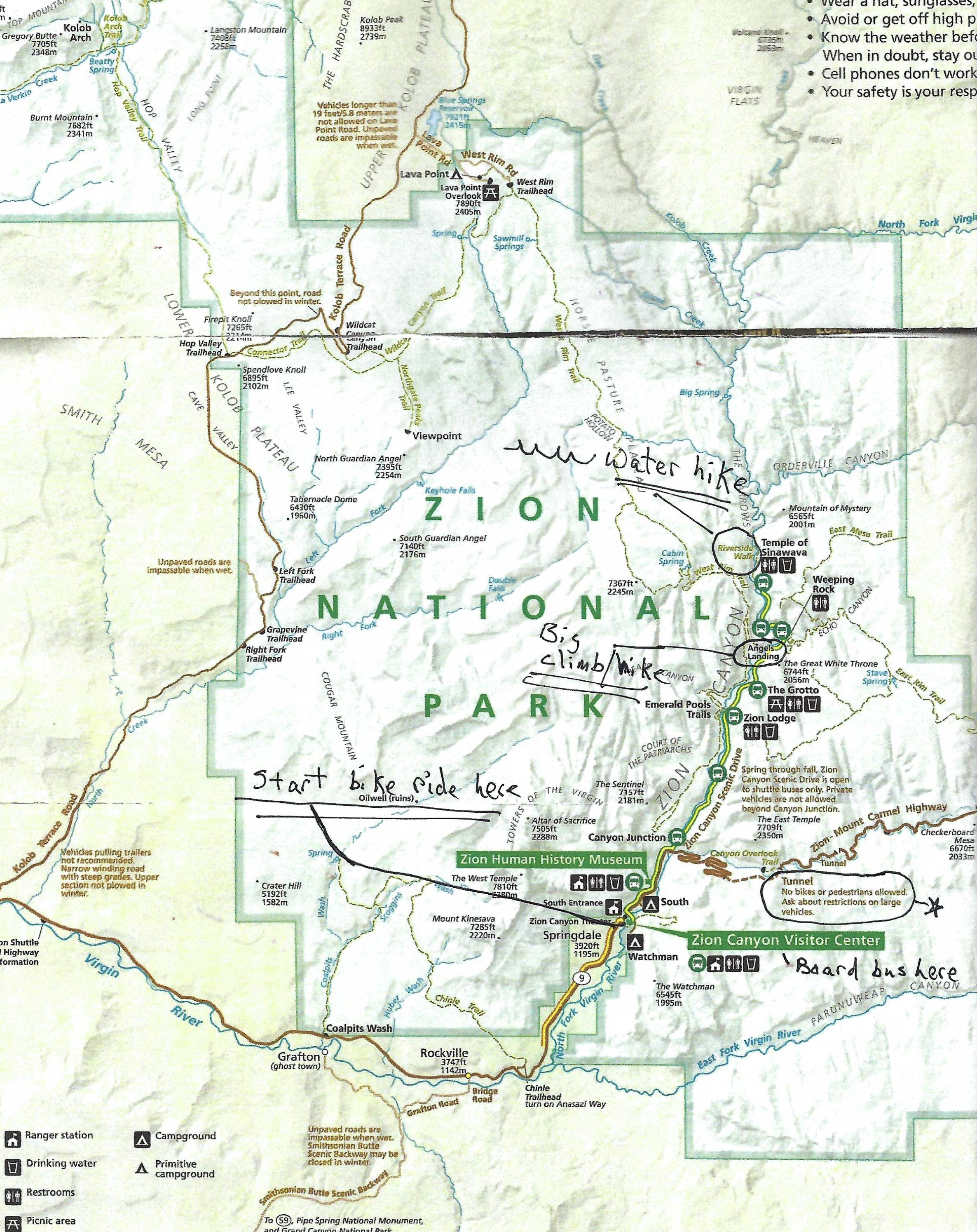
Bicycles are not allowed in the tunnel on the Zion-Mount Carmel Highway, but there is a fine place for bike riders in the Zion National Park: A paved highway with no cars allowed. The only motorized vehicle bike riders will see are buses bringing in hundreds of tourists who may hop out to hike on various trails or just sit back in their bus seat and make that their visit to the park.
Here are the rules for the buses and bicycles: Bikes can’t pass buses. A bus will pass bicycles when the rider has stopped and has his or her feet on the ground, which is required when a bus is behind you. (I only saw one pair of riders who did not follow this rule, maybe unaware of it or pursuing that day’s yellow jersey.)
We rode to the end of the road and the Temple of Sinawava trail, turned around and rode back for a pleasant 16-mile ride with no traffic on a flat paved road.

That was not enough daily exercise for this group. After changing clothes, we got in the long coiled snake of a line to get on the buses heading to the Temple of Sinawava. Many people on our crowded bus carried long wooden poles and wore black and orange shoes with gaskets around the ankles. What was that all about?

I did not find out until we got to the terrestrial ends of the Temple of Sinawava trail. That’s where the aquatic portion of the trail begins; the shoes to keep feet dry and the poles to help prevent falling as you wade up through the Narrows in the Virgin River.

The trail, both on land and sea, was crowded the day we were there, as, I bet, it is every day of the summer months. We could have avoided those crowds by getting off the bus at the start of the trail to Angels Landing. That would entail 22 switchbacks and chains to grip so you did not make a landing of your own. Anne had done the hike/climb, but it looked like I showed up 50 years too late to take this one on.

Galapagos Islands: wildlife galore, from sea to sky
Monday, October 1, 2018, to Friday, October 5, 2018 — Time to leave Quito, Ecuador, and our Alexander + Roberts guide, Maria, here competing against Sunday morning church bells in the main square. She has another group coming into Quito on Monday afternoon to do the same trip we have made in reverse – Ecuador first, then Peru.
We are leaving this land of volcanoes to a group of islands 645 miles off the coast of Ecuador, where we will spend the next five days. In 1959, Ecuador made the Galapagos Islands a national park, and it became a UNESCO site in 1996. The archipelago includes 19 islands; just five of them, where potable water was found, are inhabited by human beings. That’s about 3 percent of the land mass for humans and the rest national park, where about 95 percent of the natural wildlife is still intact.
 We traveled around the islands aboard La Pinta, staffed with three naturalists, chefs who knew their way around the kitchen, a helpful crew to sail the boat and help us in and out of our wetsuits and the pangas (Zodiacs or small boats).
Five days of hiking, snorkeling and exploring the islands’ coastlines by boat. Hard to beat.


First stop was Santa Cruz Island, where we visited what seemed to me to be a tortoise farm. The tortugas, weighing as much as 500 pounds, are not in captivity and can leave through fences to seek food. But they come here for the guava fruit and grazing on grasses, leaves and bananas. Not carnivores.
Those that are hatched here are kept for five years until their shells are strong enough to be released by the park.

Then from turtles to iguanas, seals and lots of birds. I’ve seen more variety in fish when snorkeling in Hawaii, but I’ve never swum with a seal before. Tried to get a picture with my underwater camera ($110 Nikon Cool Pix, highly recommended), but he took one look into my mask and took off while my finger was trying to find the shutter button.

The naturalists accompanied us on treks around the islands and also gave lectures each night, one on fishes, land iguanas (did not see) and my favorite, on penguins. There are about 17 kinds of penguins — more or less with some dispute on that — and all but one lives in the Southern Hemisphere. That one is the Galapagos penguin, which is close enough to the equator to drift into the Northern Hemisphere. The lecturer pointed out that the Galapagos Islands are the only place in the world with both penguins and flamingoes – except for Las Vegas, interjected Mimi, a witty member of our group.

Once Galapagos penguins numbered over 2,000 birds, but they are down to about 1,200. The biggest threat is El Nino, a weather condition where the ocean current pushes warm water east into the islands and the coast of South America. The penguins live on the west side of the islands because the underwater current churns up cold water with lots of food. The El Nino reverses that, causing the biggest drop in penguin population. Other threats include:
- Pollution from lead and cadmium, which may come from underwater volcanic sources rather than human contamination;
- Fishing when birds are tangled in nets or caught as by-catch (unintended);
- Tourism, overpopulation by the 100,000 who visit each year;
- Predators — feral dogs and rats are the worst. Goats used to pick the islands clean, but they have been mostly eliminated in a park eradication program;
- Diseases brought by migratory birds.
Besides the island of Santa Cruz, we visited the islands of Bartolome, Santiago and Genovesa. We saw birds, birds, birds. And I’ll leave you with that on this last post from our trip to Peru and Ecuador, which was a buen viaje.


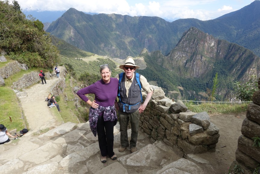
Machu Picchu: Comparing a visit in 1975 to a visit today

Tuesday and Wednesday, September 25 and 26, 2018 — Since returning from our trip to Machu Picchu, I have been comparing our visit there to one that my friend Jeff made in 1975. His experience there seems almost impossible for the Peruvian ruins now.
He took the train up the Sacred Valley to a very deserted place, as he remembers it, which today is probably the busy town of Aguas Calientes. There was only a miniature school bus run by the rather dilapidated hotel at the top of the mountain next to the ruins. So Jeff hiked the switchbacks up to the ruins, planning to camp up there.
He toured the ruins, remembers that there were a couple of Peruvian students there to hire as guides. There were not more than maybe 30 or 35 people in the entire site. The hotel held a few people, mostly older. But Jeff bedded down in one of the enclosed stone structures. The next day he hiked up to the Sun Gate and then headed down to the train to continue on his journey through South America.
Now the buses run from 6 a.m. until closing time when guards (attendants) chase everyone away. The max they allow at the ruins each day is 2,500, but word has it that anyone willing to buy a ticket is let in.
I’m glad Peru has developed a tourist industry, and Machu Picchu deserves to be the star of the show. Foreign cash welcomed there, and it’s better than visitors scared away by the Sendero Luminoso. But it does make me wish I would have continued on with Jeff from Central America in 1975, although grad school paid off in the end.
Not sure how good the student guides were, but the modern day ones are excellent – at least Yakelin was. Our two-day tour was filled with facts, observations and numbers.
It probably took 40,000 people to build Machu Picchu, most of them doing their “mita,” two years of labor as a tax to the Inca Empire. It was built there because of water sources, a quarry of stones to build with and perhaps some idea of defense because of the cliffs surrounding it. But with eight ancient trails leading into it, defense may not have been the highest priority. It may have been an advance post for the Incas move into the Amazon region to take over supply of coca leaves (a mild stimulant that helps with altitude sickness, not cocaine, which came later).
The terraces were used for agriculture with drainage built into them, and the place could support a population of 500 to 700 residents. The stone temples and houses, once covered with thatch roofs, were built between 10,000-foot Machu Picchu – the Old Mountain – and Wayna Picchu – the Young Mountain.

There are ruins and a Moon Temple up on Wayna Picchu, but we did not have time to climb it. You need a permit, and we had a schedule to keep. We were up at 5 a.m. on our second day to get to the front entrance before the buses started to arrive. My second cup of coffee put us behind two early-arriving buses. So we joined the crowd of about 200 people who all had the same idea we had: Hike to the Sun Gate, a thousand feet above the main ruins. Four-hour hike up and back for us, and too cloudy to get much of a sunrise. However, the view up there is worth the climb.
The best way to avoid the really big crowds is to stay late in the afternoon (maybe walk down to Aguas Calientes or dig deep into your wallet to stay at the post-1975 hotel next to the entrance) or go early, getting in line for the first buses climbing the switchbacks up to the site. Your best shot at getting off by yourself is to climb Wayna Picchu. A climb Jeff and guidebooks say can be tricky with the last 20 meters on steep rocks with a ladder and rope to help out. Only 400 are allowed up there each day – 200 at 7 a.m. and 200 at 10 a.m.
The authors who wrote the guidebooks we used have a longing for the past – fewer crowds, fewer people “reconstructed” the ruins. Peter Frost in “Exploring Cusco” says that when the anthropologists arrive, the gods depart. Too much work to get everything down to bare stones with no vegetation, no lichens, no wilderness to entrance the imagination into picturing what it once was. Too many government departments with some control over the site. Too much intervention “where entire walls and even buildings have been assembled upon little more than a vestige of the foundations. Visitors are presumed to be insufficiently intelligent to imagine how an unreconstructed site might have looked.” He says that having seen the ruins before and after reconstruction and he “immoderately begs to disagree.”
Yakelin pointed out that there some terraces that have not been dug up yet, but they are far down the mountain and not easy to see.
Ben Westwood in the Moon Handbook “Machu Picchu” notes that the millions visiting there each year has the site, built on a man-made mound of earth, actually sinking, “albeit very slowly.” So get there before it slips away. It’s right up there with my other favorite pre-Columbian archeological site, Tikal in Guatemala, which has unreconstructed temples that allow your imagination to run wild.
When you do visit Machu Picchu, do as Peter Frost asks: Don’t litter, don’t remove stones, plants or animals. “Remember, the Machu Picchu park is a sanctuary: for ruins, for wildlife, for trees and flowers – and for you. Please treat it that way.”

Take me down to the Rogue River Valley
Put eight friends together, add a good wilderness host, a great river and a well maintained trail for four days of rafting and hiking — minus the fires — and you’ve got a winning combination of summer fun. We set out on July 25, 2018, for the Rogue River in southern Oregon, and here’s a quick summary of a trip you ought to consider:
Thursday, July 26, 2018: Smokey because of the nearby forest fires and our guides, Dan and Ben, reminded us to leave our car keys behind in case they needed to move our cars at the Morrisons Rogue River Lodge near Merlin, OR. With a warning that we would be exposed to the sun while hiking, we set off on a five-mile trek. And it was hot — over 100 degrees. Lots of ups and downs. Stopped to view the Whiskey Creek cabin, whose last resident miner lived there from 1956 to 1973. We could have hiked farther or get in the rafts. We chose rafts. Nice seat upfront with lots of looks straight down to the bottom of the waves as we went through rapids. Swam twice with a nice float down to Black Bar Lodge.
Friday, July 27, 2018: Breakfast at 8 and we had our bags packed so Dan could take us across the river for that day’s hiking by 9 a.m. Long switchbacks up to the trail and then four miles of mostly flat path, cooler morning and more shade. I thought we might default to the raft early, but instead we chose to hike another three miles. Last half hour was very hot, and lunch came just in time. Kathy and I got the “Princess cruise” seat in the gear boat — no paddling. Dinner at Marial Lodge with the rowdy San Diego crew, who were doing an all-rafting trip. Nice talk on the porch under a faraway osprey nest, which you might notice in the video above (thank you iMovie for this preview of a slideshow). Rob shot that with his camera through a scope zeroed in on the nest. Nicely done.
Saturday, July 28, 2018: All hiking today, either 5.9 miles (according to Dan) or 9.2 miles (according to Barb’s GPS). Dan, of course, stuck by his estimate, pointing out that with no cell service GPS didn’t work here. When someone pointed out that would probably mean less mileage recorded, Dan had an answer to that, too: The signal gets bounced back and forth, meaning you get twice as many miles than you walked. Several stops on the trail today: Up the Mule Creek canyon, toured the Rogue River Ranch (restored in 2016), jumped off cliffs into the swimming hole, visited the Zane Grey cabin and saw a bear before heading on to the Paradise Bar Lodge where Dan and Ben served a great lunch of sandwiches on homemade bread from the Marial Lodge, chips and cookies. While sitting on the veranda of the Paradise Bar Lodge, we watched a deer swim across the river. Dinner, lots of jokes and stories on the veranda.
Sunday, July 29, 2018: Great last day: five miles hiking, couple of big rapids on the river and lots of floating in the Rogue. Taco salad for lunch. Trail mostly flat with not much exposure to the sun. Looking down into the rock canyon on this part of the trail made me want to see the whole river from the raft — which we plan for 2019. Back in the water for a nice float to the take out spot. While on the ride back to Morrison, we were told that the lodge had been evacuated because of fires and our cars had been moved. We had planned to stay there, but they had booked us a place in Roseburg, about 50 miles north of there. Kinda crazy at Merlin that day with reservations being remade, boats coming in, cars parked here and there and unpacking to get done. Gotta say that if Rogue Wilderness Adventures can get through all that without making you feel like one more trivial piece in a world of impending disasters, they have got their shit together. Can’t wait for a return trip.
What would you do on a rest day after biking 375 miles?
June 12, 2018 — Rest day

It’s our rest day in Medora, ND, just outside the Theodore Roosevelt National Park, and what do we do? Go on a hike, of course.
We’ve already ridden more than 375 miles on our bikes, but now it’s time to stretch our legs in a different way.
We had our breakfast at the Farmhouse Café with the same Macedonian waiter who waited on us for lunch the day before. Like all help around the United States’ national parks, it’s fun to spot the nametags of where all the serving staff, desk clerks, housekeeping and store clerks are from. We had a wonderful spinner of tales from a Southern state at the Ferris Store. We had a very attentive young woman from South Africa for our server that night at the Theodore Restaurant in the Rough Rider Hotel (celebrating Kathy’s birthday).
It’s this hotel and the nearby Ferris Store that got this place up and running. That’s when Harold Schafer – the man who brought us Mr. Bubbles — bought these two places in 1962 and started putting together the village that helps support the national park, bringing the good times out to the Badlands, aways from much else.

Now we are four, with Don flown in from Cincinnati. We drove the truck on the 36-mile loop that goes through the southern portion of park. Saw bison, wild horse and many, many prairie dogs.


We stopped at Jones Creek trail head and had a nice picnic out of the back of the truck before our three-mile hike. We were warned by a trekker coming off the trail to watch out for ticks, which he was shredding from his back. We made it through with no bloodsuckers that needed to be glad to get out of our skins.
We didn’t go to the “rootin, shootin” Medora Western Musical, see an impersonator tell Theodore Roosevelt’s story here or eat at the Pitchfork Steak Fondue restaurant. We didn’t stop at some of the old cabins and other structures that were here when TR made this his way of growing up and then putting it back together after his wife and mother died on the same day.
It’s the kind of remote (where did this landscape come from?) setting that makes a human admit he needs to make it on the land by himself without too much help from the dry, uneven earth around him.
But it is beautiful, and I hope the faux TRs don’t give it away.
From the mission statement of the Theodore Roosevelt Medora Foundation:
“PRESENT opportunities for our guests to be educated and inspired through interpretive programs, museums and attractions that focus on the Old West, our patriotic heritage and the life of Theodore Roosevelt in the Badlands.”

Trump takes his slice to America’s lands

I hope you took my advice back in October when I recommended 10 places you should visit before they died. If you wanted to see Bears Ears and Grand Staircase – Escalante National Monuments without oil rigs, you should have left for Utah last night.
A man who thinks wilderness is the long grass beside a golf fairway on Monday signed orders to slice these two areas into five separate areas and reduce their size by 85 and 46 percent respectively.
Lawsuits have already been filed to challenge this largest ever reversal on protecting national lands, and it is in the courts that the best – or the worst – outcome will be determined from today’s assault on the Antiquities Act of 1906, which brought our country’s national monuments into existence.
If the slicer gets his way, then you better make plans to get to the other national monuments that were on the original gift list for the oil, gas and mining industries.
Head to Arizona and stay awhile in the Grand Canyon-Parshant National Monument. Words on its website are calling you: “solitude, isolate, expansive landscape, natural and cultural history, undeveloped landscape, journey into the wild.”
Then head south to the Ironwood Forest National Monument. Named for a tree that can live 800 years, the Monument includes the Los Robles Archeological District, the Mission of Santa Ana del Chiquiburitac and the Cocoraque Butte Archeological District, all listed on the National Register of Historic Places.
Also in Arizona: the Sonoran Desert National Monument, offering a forest of the saguaro cacti. Every one of these signature succulents deserves protection.
Then head north into Colorado where the Canyons of the Ancients awaits. Ten thousand years of human habitation here, and a stop to see exhibits and films about the Ancestral Puebloan culture seems a must.
In Nevada, there’s the Basin and Range National Monument, where we might catch a glimpse of the wild horse herd, which ought to be given plenty of room to roam.
On to California, perhaps on the longest remaining undeveloped stretch of storied Route 66, which is in the Mojave Trails National Monument along with Native American trading routes and World War II training camps.
Six of the monuments on the original slice list were in California, so plan on a long visit there. The Pacific Crest Trail Association is fighting to make sure two of these monuments remain intact since the 2,650-mile path from Canada to Mexico passes through them. Better grab your pack and make the 30-mile trek on the trail through the desert, forest and mountains of the Sand to Snow National Monument.
You’ll need more time for the 87 miles of the PCT through the San Gabriel Mountains National Monument, and you’ll probably see more people because it serves as an escape valve for nearby Los Angeles County – reason enough to protect as much as possible to give these city folks room for healthful outdoor activities.
Urban and agriculture growth has taken over most of the grassland that once covered California’s Central Valley. The Carrizo Plain National Monument protects what’s left and should remain untouched to continue doing so.
Same with the Giant Sequoia National Monument, which guards the only conifer forest where the world’s largest tree grows naturally.
Yuki, Nomlaki, Patwin, Pomo, Huchnom, Wappo, Lake Miwok and Wintum. Those are the peoples who thrived for 11,000 years in what is now California. The Berryessa Snow Mountain National Monument website says the 330,780 acres under protection are “dense with cultural sites.” If Secretary of the Interior Zinke and his boss get to continue their giveway this monument would inevitably leave some of these sites vulnerable.
Stinkee Zinke (that had to be his schoolyard name) said he saw no need to destroy the following national monuments, but there is one good thing you can say about the former Navy SEAL: He follows orders. Gut the national lands other have preserved, orders the slicer-in-chief, and Stinkee guts them. If the Big Cheeto gets his way on Bears Ears and Escalante, nothing is safe.
So add this to your itinerary: Plan a paddle in Washington state in the Hanford Reach National Monument – 33 miles on the last undammed stretch of the Columbia River. It’s home to migratory birds, spring wildflowers, butterflies and elk. The Monument is across the river from the off-limits Hanford Site, which produced the plutonium for the atomic bombs dropped in WWII. Let’s hope this quote on the Monument website holds true: “Born of fire and ice and flood over millions of years, preserved through the war and conflict of half a century, now protected forever.”
Heading east to Idaho for hikes in the Craters of the Moon National Monument, anywhere from a half hour to multiple days through a moonscape on Earth.

Last stop is in Montana at the Upper Missouri River Breaks National Monument, which, the website says, has “remained largely unchanged in the nearly 200 years since Meriwether Lewis and William Clark traveled through it on their epic journey.” Future generations of paddlers and wanderers should have the chance to see the White Cliffs and surrounding lands these early Americans wrote about.
The emphasis in the Trump order and Zinke’s comments has been on local control, allowing state and local officials more say on land owned by all Americans. The lands will be opened to private extraction industries such as timber or oil and gas interests, which is most obvious in the “review” for five marine National Monuments — Marianas Trench, Northeast Canyons and Seamounts, Pacific Remote Islands, Papahanaumokuakea and Rose Atoll. Trump’s order entitled this section “Implementing An America-First Offshore Energy Strategy” and gives the rubber stamp to the Department of Commerce (in consultation with the Secretary of the Interior).
Those marine areas are faraway places, but Civil Beat in Honolulu has a remarkable series of stories told in words, photos and videos that can take you to one of them. Check it out at http://www.civilbeat.org/projects/the-last-wild-place/
And get traveling.
10 places to visit before they die

Anyone who thought national monuments had a chance of staying intact under the Trump administration can put that notion to rest.
Secretary of Interior Ryan Zinke’s report to Trump finally came out of hiding thanks to the Washington Post. Submitted in late August but kept secret until leaked in mid-September, the memorandum recommends shrinkage or management changes to seven national monuments on land and three at sea. The management changes would reduce restrictions on grazing, logging, coal mining and commercial fishing.
There is only one good outcome from Zinke’s continuing effort to turn the Interior Department into a real-estate agent for special interests: A bucket list in reverse.
Lovers of the wilds, pack your bags and visit the national monuments on Trump’s list before they die.
Get to Bears Ears National Monument quickly and rush to the Kane Gulch Ranger Station for one of the 20 daily permits issued to visit Moon House. It may be your last chance to get a photograph of the 1,000-year-old multi-story Native American ruin without an oil rig in the background.
In his interim report on Bears Ears, Zinke called for shrinking the monument’s area and separating out those “that have significant objects to be protected.” Given that there are archeological sites and fascinating rock formations in all nooks, crannies and canyons of Bears Ears, Zinke’s flawed idea would appear on a map as strands of spaghetti, missing “significant objects” that need the protection of the full area now designated as national monument.
You’ll be close to the Grand Staircase-Escalante National Monument, also in Utah and another Zinke-wrap target. Designated in 1996, it’s the largest national monument in the United States. That could change soon, so hurry to check out rock art and granaries from the ancient Anasazi and Fremont cultures as well as fossils from the end of the dinosaur era.
There are two Trump targets in New Mexico: Organ Mountains-Desert Peaks National Monument near Las Cruces, and Rio Grande del Norte, about 12 miles northwest of Taos. La Cueva in the Organ Mountains has provided shelter dating back to 5000 B.C., but it is going to need some protection of its own to stay intact. Conservation groups and concerned citizens, get busy.
Then head west to Nevada for the Gold Butte National Monument, designated late in President Obama’s term, which was sure to make it a prime target of the man who has promised to erase all things Obama whether it makes any sense or not. Right now there’s lots of rock art and the ghost town that gives the place its name.
The Pacific Crest Trail Association has joined the fight to keep the Cascade-Siskiyou National Monument whole. That’s because the 2,650-mile path from Canada to Mexico passes through it.
Hikers on the 38 miles through the monument in Oregon and California should brush up on geology: To the south are the Siskiyou Mountains, 425 million years old if a day; to the north, the younger, volcanic Cascade Range. This variety in geologic features is the basis for a wide range of habitat in the monument, including lots of trees Zinke would like to see cut down.
The Katahdin Wood and Waters in Maine is another place where Zinke would like “active timber management.” The area didn’t meet the 100,000 minimum acreage called for in Trump’s executive order seeking the monument review. But the governor of Maine, an early supporter of Trump, wanted its designation rescinded. There’s no Zinke shrinkage recommended, but commercial logging could be in the offing.
And commercial fishing would be allowed in two marine national monuments in the Pacific Ocean (Pacific Remote Islands and the Rose Atoll) as well as Northeast Canyons and Seamounts in the Atlantic.
The emphasis in the Trump order and Zinke’s comments has been on local control, allowing state and local officials more say on land owned by all Americans. Even opponents of the monuments concede that transferring more control of Americans’ legacy makes it more likely that the lands could be opened to private extraction industries such as timber or oil and gas interests. Which means that the Trump and Zinke charade is mainly a way of transferring national monuments to the control of multinational corporations under the false pretense of “more local control.”
Get your bags packed and start traveling.
Bears Ears Monument: Day Three

“Walk up any of these canyons and you’ll find ruins,” said Brad, a helicopter pilot from Hamilton, MT.
I met him and his wife, Mary, on the hike to a panel of ancient petroglyphs in the Butler Wash complex. I had been directed to the area by – who else? – Steve the tourist information cognoscenti. There were five ruins on the map Steve had given me, all along a sandy, hilly and curvy road that passed trails leading to the sites.
I had started the morning by saying goodbye to Jerry and Cathlet (I may have that spelling wrong), who had camped beside me the night before at the trailhead to Fishmouth Cave. Climbers and rock-art aficionados, they had moved from the East Coast within the past year. From talking with them in the evening, it appeared they were making good progress on visiting all the West had to offer in Ancient Puebloan remains.

My morning started with the hike up to the cave and a visit to the ruins along the way. We have lived in our home in Seattle for almost 40 years, and during that time we have had the chimney “tuck-pointed” at least twice because of crumbling mortar. Yet here were walls that had withstood perhaps a thousand years with the mud mortar still intact. But then it doesn’t rain nearly as much here and the rock overhangs afford ample protection from the elements.
Of the five sites indicated on the map Steve gave me, I figured I had time to visit two of them before my visit to Bears Ears ended later in the day. After Fishmouth Cave, I chose the “Procession Petroglyph Panel” as my next hike.
The trail there was longer and steeper and mostly out on open rock, a surface I’m not used to. You can’t follow footsteps from previous hikers or a trail carved into the earth. Fortunately, cairns marked the way up, and I had Brad and Mary to follow down a different route.

I wondered if the petroglyphs represented a hunt for the deer pictured. The line of human figures could be in a procession, as the name of the place suggests, but they could also represent a line of people waiting for the deer to be herded toward them for the kill. Probably some wise archeologist has an explanation of what the drawings mean, but it’s also fun to use your own imagination to decipher what the long ago artist had in mind.
 The lunch spot was at the top of Comb Ridge above the petroglyphs with a view over the entire Bears Ears area. The sun shone, my Honey Crisp apple savored and Brad and Mary’s black lab ate the core, eliminating the need to pit the sticky remains in my pack.
Brad’s route down gave my creaky knees a challenge, but I’m glad I followed them for a new experience in hiking, scrambling over boulders, scoping out the route between bigger rock formations and then inching my way down the biggest expanse of rock to rejoin the marked trail.
Driving out to the highway that would take me out of Bears Ears, I passed the trailhead to the “Double Stack Ruin.” I had already forgone Cold Springs Cave and Monarch Cave. Until I get back, I’ll be working to protect them from Interior Secretary Finke Zinke and his boss who thinks an outdoor adventure is leaving a gated community.
Save the Bears Ears National Monument for all Americans to enjoy.
