
Category: Rivers
EXPLORE Act: How did I miss it?
The Senate has unanimously passed the EXPLORE Act, which is now headed to President Biden’s desk for signing. The House passed it in April. As this article points out, the bill includes the Biking on Long Distance Trails Act (BOLT) to identify and create more long-distance bike trails, the Protecting America’s Rock Climbing Act (PARC) to safeguard Wilderness climbing, the Simplifying Outdoor Access for Recreation Act (SOAR) that will improve recreational permitting for outfitters and guides, and permanent direction for the Outdoor Recreation Legacy Partnership and FICOR.
Never saw the passage of this bill coming, But glad it is becoming law before January 20, 2025.
For full text of the bill, see here: https://www.congress.gov/bill/118th-congress/house-bill/6492/text
Utah bike ride, Day 5 — and a hike, too
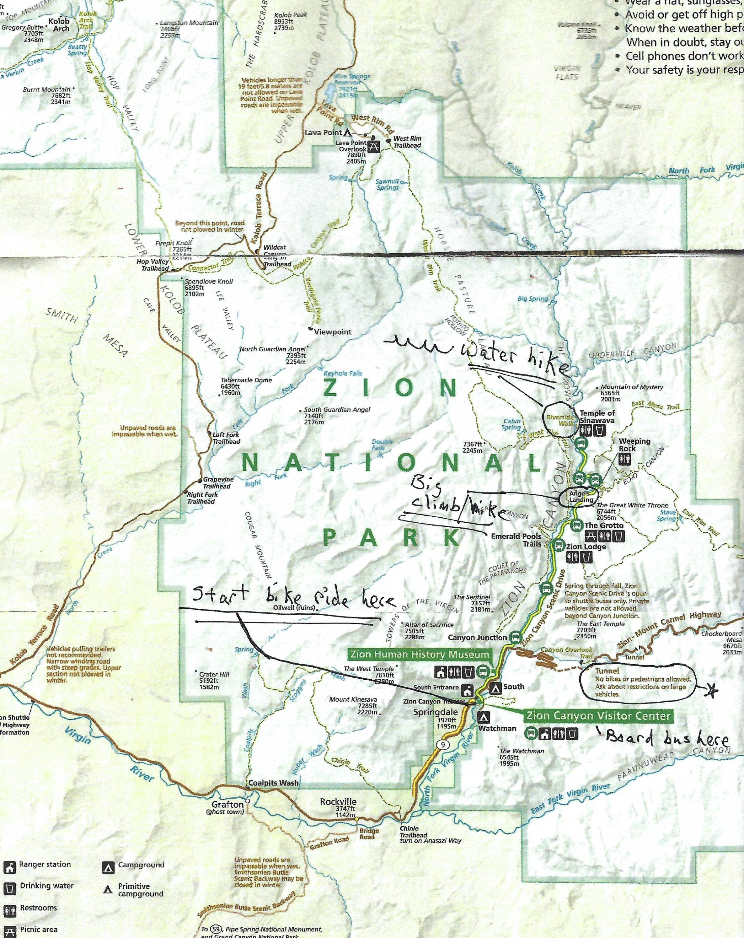
Bicycles are not allowed in the tunnel on the Zion-Mount Carmel Highway, but there is a fine place for bike riders in the Zion National Park: A paved highway with no cars allowed. The only motorized vehicle bike riders will see are buses bringing in hundreds of tourists who may hop out to hike on various trails or just sit back in their bus seat and make that their visit to the park.
Here are the rules for the buses and bicycles: Bikes can’t pass buses. A bus will pass bicycles when the rider has stopped and has his or her feet on the ground, which is required when a bus is behind you. (I only saw one pair of riders who did not follow this rule, maybe unaware of it or pursuing that day’s yellow jersey.)
We rode to the end of the road and the Temple of Sinawava trail, turned around and rode back for a pleasant 16-mile ride with no traffic on a flat paved road.

That was not enough daily exercise for this group. After changing clothes, we got in the long coiled snake of a line to get on the buses heading to the Temple of Sinawava. Many people on our crowded bus carried long wooden poles and wore black and orange shoes with gaskets around the ankles. What was that all about?

I did not find out until we got to the terrestrial ends of the Temple of Sinawava trail. That’s where the aquatic portion of the trail begins; the shoes to keep feet dry and the poles to help prevent falling as you wade up through the Narrows in the Virgin River.

The trail, both on land and sea, was crowded the day we were there, as, I bet, it is every day of the summer months. We could have avoided those crowds by getting off the bus at the start of the trail to Angels Landing. That would entail 22 switchbacks and chains to grip so you did not make a landing of your own. Anne had done the hike/climb, but it looked like I showed up 50 years too late to take this one on.

Tattling on the paddle boat
If a guided rafting trip were a Las Vegas casino, the paddle boat would be the craps table. That’s the noisy hub in the center of the room where every winning number rolled is met with shouts, cheers and high fives. And with every rapids successfully passed, those in the paddle boat shout, cheer and raise their paddles in an elevated high five.
I spent 11 of 15 days in the paddle boat on a Colorado River rafting trip through the Grand Canyon in September and October of 2023 – from Lee’s Ferry to Diamond Creek. I spent the other days as a rider in the relative calm of oar boats, a guide pushing us downstream, answering questions on stream flow, the geology and history of the canyon – the sort of conversation you might have with a dealer and others sitting around a blackjack table.
And, if this were a Las Vegas casino, I would abide by the spoken rule that “what happens in Vegas, stays in Vegas.” But that was never said on our rafting trip so I feel free to tattle on the paddle boat.
The women on the trip outnumbered men, 2 to 1, counting the clients, the guides and the accompanying string quartet. So I was in the paddle boat some days with five strong women paddlers and a female guide, the strongest of us all. The conversations often were on the distaff side of things. On the second day, one of the women complained that the personal flotation device (PFD) felt more like a corset than a life preserver. Another brought up that she had been in a play (wedding or some other event) that required outdated female undergarments, including a corset. Someone had to put a leg up against her back to pull the laces tight enough, she said. That was too much for her and she preceded without the corset. She did mention that the corset pushed her boobs so high they looked like balloons. This led to a discussion on huge boobs. One said that her mom had huge breasts, and she prayed that she did not get them. Prayer answered. The corset rejector remembered her mother’s breasts as “humongous watermelons,” and she also prayed to not get them. Another prayer answered in part. Maybe cantaloupes or beefsteak tomatoes. Speculation surfaced on whether there is a goddess responsible for boob prayers.
The next day the conversation turned to menopause. I had little to say.
Neither did I participate in the effort to liven up the mnemonic device for remembering the layers of rocks that make up the Grand Canyon. Our crowd needed something more lively than, “Know Canyon History. See Rocks Made By Time.” Someone, maybe on one of the oar boats, or in another time and place, had a more sexy version: “Kissing Takes Commitment. However, Sex Requires More Breath (and) Tongue.” But our paddle boat had a haiku writer, who challenged us to write a bawdy mnemonic device in haiku (three lines, 17 syllables with first and last lines in five syllables and the last line related but coming from a different, and surprising, direction). By the end of the day, the boat had come up with “Kink Takes Commitment. Horny Sluts Really Mingle. Bootydelicious (Times? Thoughts? Tasks? My choice: Tits – which I did not say out loud.) A work in progress worthy of sleeping on it.
Next day, a paddler finished it this way: “Kink Takes Commitment. Horny Sluts Really Mingle. Bondage Titillates.” She credited that to “what I think about under the stars.”
Worth an elevated high five.
While I can remember the mnemonic devices, I cannot remember what they stood for. That’s like remembering “A Rat In The House May Eat The Ice Cream” or “George Eliot’s Old Grandfather Rode A Pig Home Yesterday,” but not remembering what they spelled.
If you have come this far, you might think I was hanging out with a rough crowd. However, we had conversations that could have been on an oar raft. Water politics on the Colorado River and when the seven states and 40 million people depending on it will reach an agreement to stop using more water than there is in the river. History and geology (and not just ribald mnemonic devices) of the canyon. Water levels. Down to 5,000 to 9,000 cubic feet per second as opposed to 18,000 to 20,000 earlier in the summer. More rocks but the calmer parts of river moving more slowly. Keep paddling to get to tonight’s camping spot before dark.
And we talked about the rapids.
Before each set of rapids, the guides would explain what to expect and how to get through them. My wife described those explanations as, “There’s a pour-over on the right, rocks on the left and a hole in the middle. We’ll try to get through it.”
The paddle boat guide had descriptive words for the rapids. Splashy, which could be applied to a rapid or a day: “Better wear your splash gear today.” Munchy. Crunchy. Munchy not as bad as crunchy, which is often on the top of a wave and you should paddle “forward fast.”
We especially talked about Horn Creek Rapids – after they fished us out of the river.
The rapids was 90 miles into our trip, and our guide said that rather than splitting the “horns” (rocks) we would go to one side of them. The rapid drops nine feet and is rated eight or nine in the Grand Canyon style, which would be a 4 or 4.5 for the rest of the rafting world. We went into the rapids pulling hard, made the first wave and met the second one.
Because of my hearing loss, I always sat at the back of the boat near the guide so I could hear her commands. So when the boat went vertical, I found myself lying on my back in the river, looking up through the waves, my head underwater and my feet still wedged in the boat. Deciding I needed to be in the boat or out, I pulled my feet out, or maybe the river did, sank and hit something, either the river bottom or another paddler, as all six of us went overboard. I floated to the top of the waves, trying to catch a breath between them until I reached calmer waters.
At that point, my plan was to float down the river until I found a sandy beach to wash up on. But by then, several boats were around the swimmers. The paddle boat went by, but I missed it. Could not get to the second one that went by. Then I saw an oar boat coming toward me with my wife sitting in the front, waving and shouting at me, something like, “Get your ass in here!”. So I started swimming toward her boat. The guide threw out a safety line, pulled me to the side of the raft, grabbed my PFD straps and lifted me in one-handed. Then they dumped all of us back in the paddle boat, and the all female crew (except for he/him me) kept going. The guide had remained in the boat.
“Once all of you left, the boat straightened out and zipped past the wave,” she said.

The river waterboarded and frisked me. Lost my new hat, my glasses, the Croakie attached, my Do-rag that I have had forever (“Ride It Like You Stole It”), my bandana out of my back pocket and my sunscreen from my front pocket. The part of my hearing aid that goes behind my ear was left tangling but the earpiece stayed stuck in my ear hole. Overnight in magic rice from the kitchen got it working again. Worst of all, according to the guides who told us what to do if we fell in the river, I lost my paddle. Fortunately, someone else found it and returned it to me.
That night in camp, I asked our guide what the official guides’ declaration was on our flipping. She said we were rowing strongly and the boat was on the path she wanted it to be. But it was a small boat versus a big wave. “A tsunami of a wave,” as she said.
A virtual “humongous watermelon” of a wave, munchy on the way up, crunchy on the top and very, very splashy.

A rare thing on our trip: Evenly split between the men and women.
Here is a video posted on YouTube of Horn Creek Rapids. I did not film this as I was too busy swimming.
Grand Canyon photos: Rocks, colors, light


Waited 5 years for this Grand Canyon trip
You should take a rafting trip through the Grand Canyon with an outfitting company that sends along a string quartet, a fellow U.S. Census worker told me in 2010. That went on the to-do list immediately, but it took several years for the trip to actually happen.
First, we had to find time for it. Kathy retired in 2014. I retired, went back to work, retired again, work again, retire again and so on until 2022. But during my 2018 retirement, we thought we had time for the Grand Canyon trip. We called Canyon Explorations/Expeditions in Flagstaff, AZ, and they said they’d put us on the waiting list.
So we got on the list. No go in 2018. Not in 2019. And then COVID came around in 2020 and 2021. No go those years.
But it was on for August 16, 2022, with four friends from Montana, until I came down with COVID the week before. I spread the disease to six other family members, including Kathy, within a week. No one wanted us on a 15-day rafting trip, and I was too addled to paddle. The Montana friends went, and Canyon Explorations/Expeditions found us a spot in 2023.
And we went. I loved every minute of it, even getting dumped out of the paddle boat in the Horn Creek Rapids. Kathy does not like sleeping on the ground but braved the rapids, a rattlesnake she discovered on the way to the “Groover” (the ammunition box with a toilet seat that served as the carry-away poop spot) and bugs, scorpions and my snoring.
The guides were informative, helpful and cheerful. The food they cooked was hearty and tasty. And the string quartet . . . outstanding. Led by Steve Bryant, who plays violin in the Seattle Symphony, the quartet played for us in side canyons, and once, even as we floated down the river, our rafts tied together.
Now, we are back in Seattle, thinking about what the next trip will be.
And attending Seattle Symphony concerts.
Not back to Egypt yet, but here’s a good read
I’ve got at least one more post on Japan that I want to get up on this blog before I return to our trip to Egypt. But here is a very good read from a blog I follow. John Wreford raises some of the same issues on water, the Nile and Egypt that I have made. But he is on a cycle, visiting farmers and quoting Herodotus.
Dear Nile and Colorado rivers, don’t stop giving


Every article or book I have read about Egypt includes this quote from Herodotus (circa 490 — 425 BC): “Egypt is a gift of the Nile.”
So there. I have included it, too.
But I wonder if the Nile River might some day take back that gift or stop giving. Especially as Egypt and the 10 other countries that the Nile runs through “mistreat” the river.
Earliest traces of humans in Egypt go back 250,000 years, but the Nile’s gift started long after that when the climate changed and most of Egypt became a desert. Only place left to live was along the Nile. Today, 99 percent of 109 million Egyptians live on five percent of the land — along the Nile, according to a talk given to our tour group by Hany Hamroush. He has a doctorate in geochemistry from the University of Virginia, and returned to Egypt to teach at Cairo University and the American University in Cairo (AUC). His main research is on the impacts of the Nile River and the environmental changes in Egypt now and in the past.
The Nile gave Egypt river currents that flow south to north to float ships down the river and predominant winds that blow north to south to sail up the river. Trade, communications and finally a nation, a civilization. The Nile in Egypt comes from the White Nile, which starts in Lake Victoria in Uganda, and the Blue Nile, beginning in Ethiopia. Eighty-five percent of the runoff in Egypt comes from the Blue Nile, which brings with it lots of mud. Every year around June, the Nile floods in Egypt, bringing rich soil to plant crops in, water to irrigate them.
Until Jan. 15, 1971, when President Gamal Abdel Nasser opened the High Dam at Aswan.


The dam rises 366 feet above the river, is two and a quarter miles long, a half mile wide at its base with a road on top. No more silt from the Blue Nile, but many more megawatts of hydro power. As Toby Wilkinson puts it in his book “The Nile: A Journey Downriver Through Egypt’s Past and Present”:
“The High Dam has regulated the flow of the Nile, consigning the annual inundation — the natural phenomenon that built Egypt — to the history books.”
I could find no one who thought the High Dam was all good or all bad — and I admit I did very few man-on-the-street interviews while in Arabic-speaking Egypt. But in the reading I have done and the few people I talked to in Egypt, the consensus was “some good and some bad.”
Good because the dam brought about “medium floods,” as Hamroush put it. No more famines with low inundations. No more catastrophic floods like the one in 1927. The flood in 2021 was worse than the one in 1927 but not felt in Egypt because of the High Dam, said Hamroush. The dam produces about half of the electricity used in Egypt. Lake Nasser, the 300-mile-long waterway behind the High Dam, now has a productive fishery. The High Dam opened more land with year-round irrigation for agriculture.
Bad because the rich silt stops behind the High Dam. So chemical fertilizers must be used so that the country’s agriculture can feed the nation.
With the higher dam, more land cultivated, chemical fertilizers and more irrigation (think of the Nile as the only water source in Egypt — no rain, no snow pack inside the country), it sounds like agribusiness in the making. However, I looked for but only saw two tractors while in Egypt. Lots of donkeys, horses and manual labor. If Egypt can grow enough food by hand, more power to them.


More bad: Hamroush also pointed out that while silt is stuck behind the High Dam, there is less flow in the Nile so that any silt that reaches the Nile Delta doesn’t completely wash into the Mediterranean Sea. So the delta is sinking, and because of climate change, the sea is rising. The natural geological subsidence of the delta is 6.6 millimeters per year; the global sea rise is 3.3 millimeters per year. Doesn’t sound like much, but in 50 years it could affect four to eight million people, says Hamroush.

With more constant irrigation (mostly for sugar cane) there is more water damage to the foundations of ancient structures. Archeologist Kent Weeks discusses that in this video.
As Wilkerson puts it in his book: “The confident assertions of the High Dam’s cheerleaders, back in the late 1950s, now have a hollow ring. As one son of Aswan laconically put it, the High Dam ‘is slowly killing Egypt.’ “

And that’s not all. The Egyptians may now be paying more attention to how the Nile is treated, especially since someone else is doing the treating. Ethiopia has built and has filled the lake behind the Grand Ethiopian Renaissance Dam (GERD) on the Blue Nile. The concrete dam rises 475 feet above the river. The lake behind it covers 724 square miles (about the size of Houston, Texas). It will double Ethiopia’s output of electricity. Sounds good for Ethiopia, bad for Egypt.
For Egyptians, this could lead to ontological security—or the preservation of state identity. As this Carnegie article says:
“Ontological insecurity may arise when internal and external developments disrupt the continuity of established identities and worldviews. It could be argued, then, that the GERD project threatens the continuity of Egypt’s enacted world that sees the Nile as a living being inseparable from Egypt’s history, culture, and civilizational identity. Thus, developments related to the project could force Egypt to redefine its national identity that is centered on the Nile River.”
(Here’s another good article from the Brookings Institute.)
So the Nile could be caught between two huge dams, the High Dam in Egypt and the GERD in Ethiopia, sort of like the Colorado River in the United States, caught between Hoover and Glen Canyon Dams among others. Recently, the U.S. federal government came out with three options for how to use the water from the dwindling Colorado River, which could mean cutting off water to 10 million Americans or plugging the irrigation canals that support a “$4 billion industry that employs tens of thousands of people and puts vegetables in supermarkets across the country during the winter.”
Maybe the question more germane to the United States should be: What if the Colorado River stopped giving?
What if COVID had come a week later?
Trying hard, with little success, not to think of the timing of this COVID attack. Kathy and I went two and one half years into this pandemic without a whiff of COVID. Then a week before our rafting trip through the Grand Canyon on the Colorado River, I come down with COVID and spread it to seven of 10 family members. The only ones spared are two who have already had it and a 21-year-old who has a cold but refuses to test positive.
I also think about what would have happened if my first symptoms were a week later in Flagstaff.
Night 1: Feeling tired but it had been a long day with the orientation for the rafting trip.
2. Next morning: Some sniffles but nothing so serious that I could not get on the raft with the other 15 or so people who would be sailing down the Colorado.
Day 3 and Day 4: I would have spent these days sleeping, coughing and gulping down anything to sooth my sore throat. Muddy Colorado River water? Not a problem. Can I hang over the edge of the raft with my mouth open like whales sucking krill through their baleen?
Day 5: Guides would have pushed me overboard. If not. . .
Day 6: All guides, clients, orchestra sick in quarters. Section of river roped off to incoming rafters, who have to walk out of the canyon while the rest of us are left on our own to suffer.
I also thought about whether we canceled our trip too early. What if we had kept pushing on to Flagstaff? No travel on Days 3 and 4 (see above) when I was the sickest and Kathy came down with her first symptoms. Then it would be Friday. We’d still have time to stretch our two-day trip to Flagstaff into four driving days. We’d arrive tired and coughing, but with enough cough syrup we might get on the trip. If the company asked us to show a negative COVID test, we were sunk – probably by the other clients who saw the worst coming their way.
I’ve been over this a couple hundred times, and eventually we did what was right: Canceled, infected our family (who took wonderful care of us), then started a slow trip back home. I’m testing negative, Kathy still positive. Mostly holed up in the truck, masked when not, eating outside or in our rooms like bums under a culvert.

Also hard not to dial through everyone I met leading up to getting infected. Was it the person who sat behind us in the theater Friday night and coughed all through “Hamilton”? On the bus and light rail to my doctor’s appointment Friday morning? The clerks in the camera store where I bought three new memory cards and multiple batteries for the hundreds of pictures I was going to take in the canyon? The U-Haul clerks? Some wisp of air that had lost connection with whoever put it out there to travel up my nose. To them I say: May a bird of paradise fly up your nose, may an elephant caress you with his hose. Remember that song? Long-term memory is still intact. And I did fix my own car key (see post two back). I can read instructions. Wait. That’s new. My behavior has changed. A new COVID symptom?
A rafting trip before the river dries up
Canyon Explorations found a spot for Kathy and I on the 2023 trip. Maybe they read this piece in the Denver Post. https://www.denverpost.com/2022/07/21/colorado-river-drought-water-crisis-west/
Here’s a scary line for river rafters: “If the reservoirs drop even lower — to a point called ‘deadpools’ — officials at the dams will no longer be able to send water downstream at all . . .”
So much for future river rafting. Hoping we make it through 2023 and our once again scheduled trip.
And so much for the 40 million people who depend on the river for food and water.